The title “Martin Benet and the Black Friar” might sound like an Agatha Christie novel from the 30’s, but it is actually a walk of 5.4 km around the lost churches of St Benet and St Martin in the City of London. It starts and ends at a gorgeous pub called the Black Friar. So you can either fortify yourself before you start or celebrate when you finish in this lovely venue. There were originally 5 churches dedicated to St Martin in the City of London but sadly only one remains. Likewise, of the 4 churches dedicated to St Benet there is only one left, as we shall discover.

We start at Blackfriars. This part of London takes its name from the Dominican Friary established here in 1276. The Friars wore a black cloak or “cappa” which distinguished them from the Grey Friars (Franciscans), White Friars (Carmelites) and Crutched Friars (who carried a crucifix on a staff). All of these religious orders had Friaries in medieval London and you can still find traces of them in the names of streets and buildings around the City. The Black Friars were established in three different places during their time in London. The First Blackfriars was established in 1220 at what is now Holborn Viaduct close to where the church of St Andrews Holborn is today. The viaduct is a Victorian structure – in medieval times it was a bridge over the River Fleet which ran due south down Farringdon Street to the Thames. If you feel like attempting some time travel, then stand on Holborn Viaduct and look south with half closed eyes and imagine the road is the river.
The second Blackfriars was established in 1276 when Edward I gave permission for the the London City Wall to be rebuilt along the banks of the Fleet. So the Friary relocated to the current site of Blackfriars station on the opposite side of the river to the original settlement. It remained there until 1538 when it was dissolved by Henry VIII as part of the dissolution of the monasteries. A third Blackfriars was briefly in existence for a few years from 1556 within the priory of St Bartholomew (now Barts Hospital) but it did not last.

On the map shown you can see the layout of the buildings of the second Blackfriars. The dark purple building is the main church, the light purple the friary outbuildings and the pink the tenements and shops that the Friary leased to tradespeople. We start the walk outside the Blackfriars pub marked by the red dot – which is close to where the old kitchens and bakery were in medieval times. The pub is a well loved art deco landmark – beautiful both inside and out so be sure to check it out.

We start the walk by going down the hill past the entrance to Blackfriars tube towards the Thames and down the steps to the path along the river bank. Then as you pass Blackfriars pier you need to go up the steps to White Lion Hill and you will come out by the church of St Benet Welsh – previously known as St Benet Pauls Wharf. This is the first of the churches dedicated to St Benet – short for Benedict. There has been a church here since 1111, but this current building was designed by Sir Christopher Wren after the previous one was destroyed in the Great Fire of 1666. In 1879 Queen Victoria granted the church to the Welsh Anglicans and its services are still conducted in Welsh with English translations available.
Continue along Queen Victoria Street until you get to Lambeth Hill and then walk down past the remaining tower of St Mary Somerset. Walk along Upper Thames Street until you get to Little Trinity Lane. If you look carefully you might spot two parish boundary markers above a vehicle entrance for St Michael Queenhythe and St James Garlickhythe – but those are part of another walk (see Taking the Michael). Keep walking past the church of St James Garlickhythe and into College Street where you will find the church of St Micael Paternoster Royal. The green area to the front of this church – called Whittington Gardens – is the site of the lost church of St Martin Vintry. A parish boundary marker shown in the picture below used to be on the wall of 80 Upper Thames Street but it disappeared when the site was redeveloped. The modern blue-green glass building has a blue plaque commemorating the Joiners and Cielers but not the church of St Martin Vintry any more. The church was destroyed in the Great Fire of London and never rebuilt but we do know what to looked like from the Wyngaerde panorama of 1543 shown here. It looks like a fairly substantial edifice.


Now go down Cousin Lane alongside the bridge and tracks of Cannon St station and go through the tunnel onto the Hanseatic walk that memorialises the Germanic trading settlement that was here in medieval times known as the Steelyard. Keep walking along side the river Thames under London Bridge and then turn left to wend your way up through the buildings to the church of St Magnus the Martyr. If you go inside the church you will find a lovely detailed model of old London Bridge – with all the houses on it – which passed right through the church yard of this church. The current bridge was moved some 100 meters upstream. On the wall outside the church you will find a parish boundary marker for St Martin Orgar. This is another church destroyed in the Great Fire and whose parish was eventually merged with St Magnus the Martyr hence the boundary marker on this wall.


The tower of St Martin Orgar still stands today and you will find it by walking up to the Monument and across into Cannon Street. Immediately on your left you will find Martin Lane – named after the church – and a little way down you will see a blue plaque commemorating St Martin Orgar. The brick tower to the left of this plaque is all that remains of St Martin Orgar and the green space in front of you used to be the churchyard. Now retrace your steps back up to Cannon Street and go up King William Street to the church of St Clements. Head up Clements Lane and take a right into Lombard Court. Here you will find a number of parish boundary markers for St Benet Gracechurch. The first will be on the wall on your left, then some more right on the corner with Gracechurch Street and then across the road you’ll see a blue plaque commemorating the site of Saint Benet’s. This was another victim of the Great Fire of London but this church was chosen to be rebuilt by Christopher Wren. Unfortunately, it was later demolished in 1868 under the Union of Benefices Act and the parish combined with the nearby St Edmund King & Martyr.


There is one more parish boundary marker for St Benet Gracechurch to discover. If you duck down into Talbot Court and go around past The Ship pub you will find it high on the wall on the right alongside a marker for another lost church – St Andrew Hubbard. When you emerge from Talbot Court onto Eastcheap turn left into Philpot Lane and then up Lime Street and make your way through Leadenhall market. You should find yourself on the corner of Gracechurch Street and Leadenhall Street. Go across the intersection and turn right into the narrow alleyway of White Lion Court. High up on the left-hand side you should see a parish boundary marker for St Martin Outwich is shown in the photo.

The church of St Martin Outwich was built in the 14th century by the Oteswich family – hence its name. It was lucky enough to escape the Great Fire of 1666 but destroyed in a later fire in 1765. It was rebuilt to the designs of Samuel Cockerell but finally demolished in 1874 when the parish was united with St Helen’s Bishopsgate. If you come out of White Lion Court and head north up Bishopsgate you will find a plaque commemorating St Martin Outwich, which stood on the corner of Bishopsgate and Threadneedle Street.


Now continue down Threadneedle Street until you get to the Royal exchange if you now look back towards the east, you should see the blue plaque that commemorates St Benet Fink. The St Benet – or Benedict – that all these churches refer to is Benedict of Nursia who is the patron saint of Europe. He was the founder of Western monasticism and venerated as a saint in Catholic, Protestant and Orthodox Christian churches. The unusual name “Fink” is a corruption of “Finch”. This was a local family who are believed to have been the original benefactors of the church of St Benet in the 13th century. The nearby Finch Lane is also named after them. St Benet Fink was rebuilt by Christopher Wren after the Great Fire of London but, as with so many other churches, was demolished in 1846 under the Union of Benefices Act. Wren was tasked with creating a church in a very confined space and came up with an unusual design based on a 10 sided decagon with an oval dome on top. The watercolour shows what the completed design looked like, which was painted just before its demolition.

Keep walking down Threadneedle Street and go straight across the Bank interchange into Queen Victoria Street on the opposite side. A little way down you will find a turning to your right just behind the 80’s architectural monstrosity of No1 Poultry. This is Size Lane that leads into Pancras Lane. Here you will find a blue plaque and a carved stone memorial to the church of St Benet Sherehog. This area was the centre of the wool trading district of the City (see also the lost church of St Mary Woolchurch Haw which stood where Mansion House is today). A “shere hog” is a castrated ram after its first shearing ( I wince when I think about this in the barbers). The church of St Benet was built on this site some time before 1111 AD. We know what it looked like from the Copperplate Map of London from 1550. It was not rebuilt after the Great Fire and the parish was combined with St Stephen Walbrook.


If you now continue down Pancras lane after only 20 yards or so you will come across the open space that was the site of the lost church of St Pancras Soper Lane. This is a wonderful reminder of how close some of these churches were to each other, and how tightly packed the 110 medieval churches were in the City of London.


Exiting Pancras Lane you come into Queen Street where you need to turn right and then right again onto Cheapside. Walking back towards Bank, you will find the street known as Old Jewry on your left. If you head up there you will come across Frederick’s Place. In that street you will find some parish markers to St Martin Pomeroy and St Olave Old Jewry as shown. These two churches were practically side by side. St Martin Pomeroy – sometimes spelt “Pomery” is believed to have got its name from the apple trees that grew nearby. It is yet another church that was destroyed in the Great Fire and never rebuilt. The parish of St Martin Pomeroy was united with St Olave. You can still see the remains of the latter which has now been converted into an office building in St Olave’s Court which you will find as the next alleyway up Old Jewry beyond Frederick’s Place.

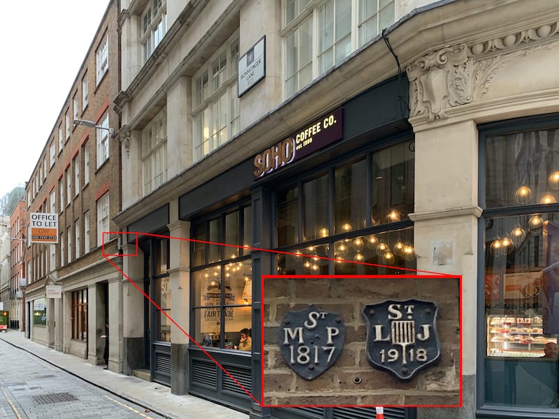
When you come out of St Olave’s Court turn right up Ironmonger Lane to find two parish boundary markers near Soho Coffee at the top of the street. These are for St Martin Pomeroy and St Lawrence Jewry. You will see St Lawrence Jewry if you turn left onto Gresham Street and then turning left again down King Street you will find two more markers for St Martin Pomeroy above Atlas House at No.1 King Street.


We have not had much luck with the “Martins” so far – every single one of them has been lost. But the walk ends with the one remaining church dedicated to St Martin on Ludgate Hill – so all is not lost. To find it follow the directions on the map to go up Cheapside and through the churchyard of St Paul’s cathedral. When you get to the steps of St Pauls and look west down Ludgate Hill you are looking down into the valley of the Fleet river. A little way down Ludgate Hill you will find the church of St Martin Ludgate. This is another Wren church built after the Great Fire and its tall steeple was designed as a counterpoint to the dome of St Pauls. If you walk further down Ludgate Hill and then look backwards you will see the two in juxtaposition – they play off each other in an interesting way which is an effect Wren must surely have planned.
Now it only remains to wend you way back to the Blackfriars pub for some well eared refreshment .
