Anyone interested in the lost churches of the City of London will struggle to find images of the churches burnt down in the Great Fire of 1666 and never rebuilt. After the fire, Sir Christopher Wren rebuilt or repaired some 50 churches of which 26 have since been demolished. But we know what those looked like from Wren’s architectural plans, from sketches on the margins of parish maps and from watercolours and engravings from the 18th century onwards.
What about the 34 churches destroyed in the fire and never rebuilt? What did they look like? That’s a much more difficult question. There are plenty of textual documents for these churches but no drawings. There are a remarkable number of surviving parish registers for these lost churches, stretching back to the 13th century. So we often know the names of people who were born, married or died there but we have little idea what the church actually look like. The best sources for trying to work this out are the panoramas of London before the Great Fire. The most useful panoramas are the Wyngaerde Panorama of 1543, the Visscher Panorama of 1616 and Hollar’s “Long View” of 1647. All three of these, for example, show the tall spire of the lost church of St Lawrence Pountney although it seems far more prominent in the later views (see below) .
Hollar’s Before & After engraving
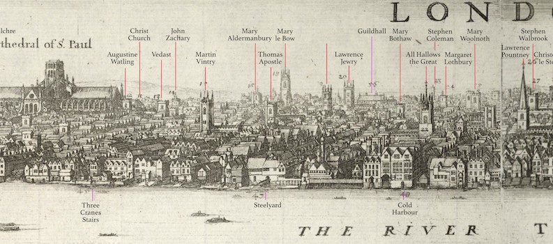
The most interesting panorama of all is the Hollar “Before and After”. Hollar sketched the devastation caused by the fire and then published a before and after panorama which I have labelled and split into four parts as shown below. The top panel shows the ‘before’ and the bottom ‘after’ so you cane compare the two side by side to see the destruction .
The title says it was drawn from the steeple of St Mary Overie (now Southwark Cathedral) on the south bank next to London Bridge. However, it seems that Hollar actually observed for more than one vantage point. I have drawn the sightlines (see below) from St Mary Overie to the churches on the north bank and they do not follow the order show in the engraving.
The areas to the far left up to to St Benet Paul’s Wharf and the far right from St Bartholomew by the Exchange onwards are all consistent, as is the part of the central section from St Lawrence Jewry to St Stephen Coleman street. The problems start in between these sections. St Peter Paul’s Wharf should be on the left hand side of St Andrew Holborn according the to the sightlines but the engraving shows it on the right. Interestingly, Hollar’s Long View of 1647 – twenty years before the Great Fire and presumably the basis for the top ‘before’ part – shows St Andrew Holborn in the correct place much closer to St Pauls.
Looking the the right of St Pauls, St Martin Vintry is on the wrong side of St John Zachary and may in fact be a mislabelled St Michael Paternoster. We known St Mary le Bow is correctly identified because of its distinctive arches (bows) and St Lawrence Jewry right next to the Guildhall must also be correct. But the others in this central section seem disordered – so much so that church number 19 has no name at all in the key at the bottom. According to the sight lines, St Stephen Walbrook should be to the left of St Margaret Lothbury but you can also see in this area a number of church towers that have not been named.
What might be the cause of these apparent ‘errors’? We know from Hollar’s sketch books that he did drawings from a number of viewpoints and assembled them for his overall panorama. If so, there there would be more than one sightline to superimpose which would then change the order. It is more probable that the publisher of the engraving mislabeled some of the churches – as the unnamed “Church 19” shows there was some confusion here.
For anyone interested in helping me untangle these issues, I have high resolution images that I can send you. You can reach at lostchurches@gmail.com


Wikipedia page on Hollar

